Review of Snowpack and Lake Levels for the South Thompson Drainage
Welcome to our 3rd report on Shuswap Lake levels and snowpack for 2026.
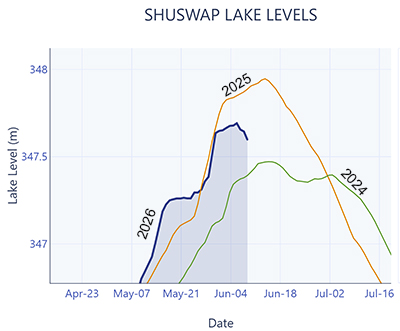
The Provincial River Forecast Centre has released its June 1 report. For the South Thompson drainage (which includes Shuswap and Mara Lakes and their tributaries), air temperatures have been above normal during the last half of May, and precipitation continued to be below normal for this period. As a result, Shuswap Lake levels continued to rise through the last half of May but, in the past week, the rate of rise slowed quite dramatically.
Why has this change in the rate of rise of the lake occurred? To explore this question, we need to look at the snowpack data across the basin and also review the watershed modelling data for the watershed provided by the River Forecast Centre.
There are four snowpack recording stations in the drainage, one north of Celista, one near Enderby, one at Park Mountain near Lumby and one at Silver Star Mountain near Vernon. Currently (June 9th) data for the Celista, Park Mountain and Silver Star monitoring stations show that the snowpack has melted completely. The highest elevation site, near Enderby, still shows that the snowpack at the site remains but has decreased to approximately 35% of the peak level recorded this year.
River Forecast Center estimates that, as of June 1, snowpack was only at 9% of normal for that time of year, a decrease of 40% from May 15th.
In conclusion, the spring runoff from snowpack is nearly over.
The River Forecast Centre also uses a watershed model to estimate river flow and lake levels across the province. These estimates are released daily during the work week and show the expected trend in the level of Shuswap Lake looking ten days into the future. The current estimates show that the lake level should decrease over the next weeks to ten days.
Finally, as of June 8th, the observed lake water level at Blind Bay appears to have reached its annual peak and is starting to decrease.
As always, the wildcard is always the weather through the remainder of June. However, the 14-day weather forecast for Sicamous indicates the continuation of generally warm, and dry, weather for the area. Thus, we expect that the lake level will continue to decrease through the remainder of June.
SWOA will continue to monitor this information and the next report from the River Forecast Centre (due to be released between June 16 and 19) and will post an update on the website if there are any significant changes expected for the lake(s)