
Update May 25, 2025
The Provincial River Forecast Center issued their May 15, 2025, Snow Survey and Water Supply Bulletin this week. Generally, across B.C., snowpack is below normal, averaging 61% of normal (39% below normal). The snow Basin Index for the South Thompson (most of which is the Shuswap drainage) shows a similar trend at 69 % of normal, down 17% from April 1st. In comparison to May 1, 2024, this year’s index was 8% lower and 5% lower at mid-month.
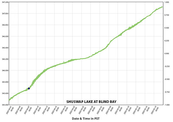
Looking at the 2025 water levels recorded at Blind Bay from late March to the mid-May, the lake level has continued to rise at a relatively constant rate (see the graph below). This steady increase is likely due to the generally warm and dry weather that through April and May and the melt of the low to mid-level snowpack on the surrounding mountains. In the last week, the rate of rise has slowed somewhat, likely due to the dry weather and the depletion of the low and mid-level snowpack
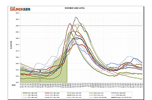
When we compare the current water level to data for past years, it is similar to the water levels recorded in 2022 and 2023 (See the graphic below showing water level data recorded at the Salmon Arm water treatment plant for the period 2008 to the present).
So, what does this mean for the rest of the spring and summer? To provide some context, we need to look at the Snow Water Equivalent (SWE) data for the four stations across the watershed. All are located at different elevations, Celista in the north being at the lowest elevation (1500m), Park Mountain (1890m) and Silver Star (1840m) stations in the eastern part of the watershed being relatively high and the station near Enderby (1950m) in the central part of the watershed at the highest in the watershed. As of May 1, the Celista station (a mid-level elevation station) recorded the lowest recorded SWE for this time of year (based on 18 years of data). The current SWE was well below normal and the trend for May is continuing to be lower and earlier than in past years. About 40% of the snow at this station has already melted (in a normal year this would be about 15% by now) and about 2-3 weeks early.
SWE data from higher elevation stations show that the melt is just beginning in the upper watershed and the timing is following a similar pattern to past years. Two of the three higher elevation stations had snow accumulation recently. The offset of the timing of the snowmelt across the basin this year will mean that we expect the continued increase in the lake level to continue well into June but perhaps peak at a lower elevation than in the past few years.
As always, the wildcard will be with the trends in the weather across the watershed. If the current trend of relatively low precipitation and cooler temperatures continue, we expect the lake to peak in mid-to late June. However, a period of heavy rain or very warm weather (as is expected in the next week) would change the rate on snowmelt and consequent runoff, possibly resulting in a higher peak water level.
As always, SWOA will continue to monitor conditions and will post updates on the website.
Click image to see full size.