June 18, 2025
The Provincial River Forecast Center issued its June 1, 2025, Snow Survey and Water Supply Bulletin last week. Generally, across B.C., snowpack is below normal, averaging 44 % of normal (decreasing from 61% May 15th). The Snow Basin Index for the South Thompson shows a similar trend at 53% of normal, down 16% from May 15th. In comparison to June 1, 2024, this year’s index is 34% lower.
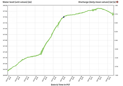
Looking at the 2025 water levels recorded at Blind Bay from late March to mid-June, the lake level continued to rise at a relatively constant rate until the beginning of June. The rate of lake level rise slowed through the first two weeks of June (see the graph below) reaching a peak level on June 14th.
Since the 14th, Shuswap Lake levels have started to decrease. This trend is also supported by the water level forecast issued daily by the Provincial River Forecast Centre, indicating that water levels will continue to decrease over the next 10 days.
Last month we talked about the snow levels (as measured as Snow Water Equivalent) at the four monitoring stations in the watershed. At the lowest station (Celista) snow has all melted. At the Park Mountain (1890m) and Silver Star (1840m) stations in the eastern part of the watershed there is little snow remaining and at the relatively high elevation station near Enderby, the snow is rapidly depleting. The early melt of the snow at these stations is earlier than normal.
All of this information is consistent with the conclusion that Shuswap Lake levels are now past the annual peak.
As always, the wildcard will be with the trends in the weather, and specifically in any potential increases in precipitation across the watershed.
SWOA will continue to monitor conditions and will post updates on the website.

Click here for Daily Water Level Graph for SHUSWAP LAKE AT BLIND BAY