Review April 2026
Welcome to our first article for 2026. Hopefully your residences have weathered well over the winter.
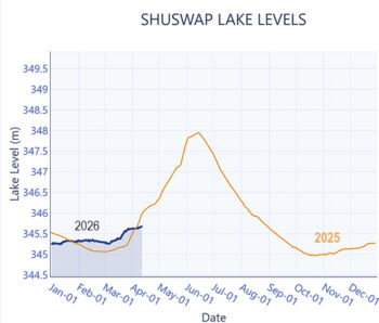
If you have managed to visit the lake already this spring, you will likely have observed that the lake level is higher than normal for this time of year. In fact, the level of Shuswap Lake reached its annual minimum in mid-October and has generally continued to rise (albeit slowly) almost continuously all fall and winter (see the attached graph). Although unusual, this is not unprecedented.
The current level is, in fact, almost the same as the lake level observed at this date last year (check the water level graphs on the SWOA website). The different pattern in the fall lake elevations can be attributed to the generally warmer, and wetter, weather in the watershed over the winter. There has been very little low level snow accumulation over the winter and much of what did fall has mostly melted.
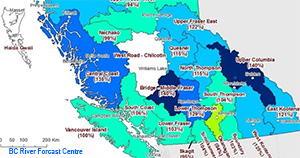
Looking forward, what could we expect over the rest of the spring and summer? The Provincial River Forecast Centre has just released their April 1, 2026, Snow Conditions and Water Supply Bulletin. Generally, they report that in the northern half of BC, winter snowpack is well above normal with some of the reporting stations showing all time high snowpack levels (as much as 134% of normal for this time of year). However, in the southern half of the province, the opposite is the case, with some stations reporting all time minimum levels. As for the South Thompson watershed, the snow water equivalent index is 85%, up 2% from a month ago but within 1% of the estimate for last year.
The only other forecast that we would want to consider is the estimated volume of the April to June and the April to September runoff. Both volume estimates are similar, calculated by the River Forecast Centre at 93% and 94% of normal.
So, the remaining variables, the weather through May and June, will dictate how rapidly the accumulated snow will melt, runoff and affect the annual peak elevation of Shuswap Lake. Normal weather would indicate that the lake level should rise at a rate as it did last year. However, if we get a very warm and wet stretch of weather through May and June, the snowmelt runoff could occur rapidly and result in a more rapid, and higher, rise of the lake levels.
At SWOA we will be reviewing the data provided by the River Forecast Centre and Environment Canada and will keep you up to date as the snowmelt occurs.